I think this is a great idea, because the trail system is not as user friendly as it could or should be. I have a typical cycling loop that is about 45km - all within the city and fairly central - and on that route I think I pass maybe 3 or 4 trail maps. For anyone who is not familiar with the river valley, the chance of them stumbling across informative signage is basically zero. So I'm glad that the city is working to improve this, and I hope that these new wayfinding tools might encourage a few tourists (or locals) to explore that trail system.
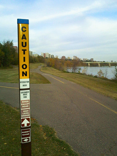
Here is one of the new signs:

First, the bad:
They're not well thought out.
They're not very helpful.
They're sort of ugly.
The giant Caution at the top of the sign makes no sense. These are multi-use trails and not a freeway. You're not traveling at 80km/h, and you don't need to be warned that there's an intersection ahead because you can see it right in front of you. And anyway, the print on the sign is so small that in order to read it you have to be standing in the intersection, looking at a sign telling you that you're at an intersection. It's ridiculous.
There is also a real risk with sticking Caution signs everywhere because it devalues locations where they might actually be important. If what they want is a yield sign for safety then they should put a yield sign - a Caution sign on a stick doesn't mean anything to anyone. Traveling through an area that has many of these signs it is natural to assume that they are just marking something like an underground utility, and that they are unimportant. Training trail-users to ignore Caution signs is the last thing that the Parks Branch should want.
The signs are also lacking a key piece of information - distances. "The High Level Bridge is up ahead somewhere" is not helpful. What's even less helpful is that if you follow this sign the Groat Bridge (which isn't listed) is less that 1km away, but the High Level Bridge is another 2km beyond that. There is plenty of room to add distances, but it is also important that the information that is listed is consistent. All nearby river crossings should be identified because they are fairly rare, and because if you cross the river once then you need to make sure you can get back. Intersections, major parks and trailheads should be prioritized as well.
Finally, the signs are unnecessarily ugly. I like to think that improved signage and wayfinding markers could help to make the river valley more friendly and welcoming, but unfortunately these signs just make it look like a crimescene. Information for trail-users should be a helpful resource and not something to be scared of.
So that is what I don't like about the signs. What do I like?
More signage is definitely needed on the multi-use trail system.
The city is going for a look that is consistent and visible and that says "This is important" rather than "This is a sign that is brown" like most of the existing signage.
The new signs appear inexpensive and should be mostly vandalism-proof, so they could be installed throughout the trail system at low cost.
How would I improve them?

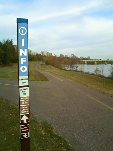
As far as I'm concerned, labeling these signs as Caution completely misses the point. What they are providing is Information, and that is how they should be identified. This is a really simple change, but I think it's a huge improvement.

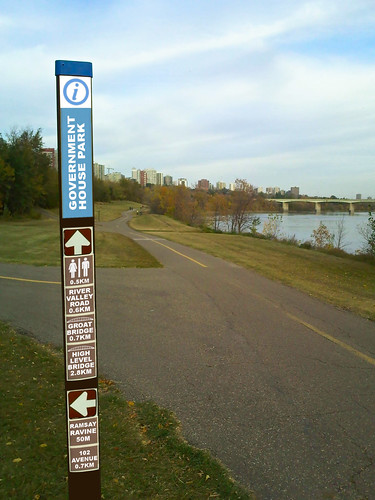
Taking things one step further, something like this contains the information that I would like to see. The text is still small enough that you need to stop to be able to read it, but it is basically an info booth - if you are lost then stopping isn't a problem. Ideally a small map of the nearby trails could also be added on the back (similar to what is done on some bus-stops), but I don't think that would fit on the signs the city has chosen. Even without that though, placing these wayfinding markers frequently and then installing eye-catching maps of the full trail system at every river crossing, major park and trailhead would make the parks system much more inviting.
The city is looking for input on this pilot project at trails@edmonton.ca
1 comment:
Nice information,, terrimaksih infonya..sukses much for sharing the info and the website is always to be the best and do the best to the kawasaki ninja h2r next information ..
Post a Comment