A 102 Avenue for People

When the Valley Line begins operations, 102ave should remain closed to traffic from 99st to 103st.

And this is why:


Why would we put cars here, when we don't need to?

102ave will be a terrible road for cars. The city did a traffic study which predicted an *18 minute wait* to turn onto 102ave.


If 102ave is opened to traffic it will be nothing but a long line of idling vehicles. So why not make it for people?


Do people actually want to be on 102ave?


Right now, 102ave definitely has a bit of a problem with monolithic malls from the 80s.

But City Centre Mall and Manulife Place have both announced redevelopment plans to open up their malls to the street, and to encourage walkability.

The former BMO lot at 102ave and 101st is currently a hole, but one day it will become something new.

Whatever that lot becomes, it won't need a single lane of idling traffic infront of it.


And honestly, the problem isn't just idling traffic:


If traffic is allowed onto 102ave, drivers will also park on the bikelane, shortcut on the bikelane, and block the sidewalk and bikelane at every intersection.


"...oh, drivers won't break the rules. That won't happen." Unfortunately the 102ave bike lane will absolutely, 100% become the "I'll just be parking here for a second" lane.

But it doesn't need to be that way.


If we were to make 102ave into a people place we could get a freebie-plaza at the north end of Rice Howard Way as part of the deal:


It is 12,000sqft, which is enough space to store 6~8 cars, or enough space to do something new:


And a few blocks west at 102st another plaza would be possible by the YMCA and Manulife Place.


The area from 102st to 103st is an interesting spot, because at this point it has been closed for years, but it will also be closed again once the construction of the West LRT begins:


There is no point in allowing traffic here again for a few months or a year, only to close it again for a second round of LRT construction. So instead, while we wait for the West LRT to begin this area could be used for programming and pilots, similar to the pop-up parks which were successful in 2021.


A decade ago someone made the decision that one lonely traffic lane absolutely had to remain on 102ave.:


But at this point 102ave has been closed to traffic for years and years. If it never reopens, no one will miss it.


There are a million reasons to rethink 102ave: climate change, vision zero, collisions with people, collisions with trains, urban placemaking, downtown redevelopment, road maintenance...
A single lane of gridlocked traffic won't save downtown, but making downtown into a place for people might.


If you would like to see the individual images which were used in this post they are accessible through google photos here.

Edmonton Bikegrid: Envision 109

This is going to be a continuation of the series of posts looking at hypothetical, future expansions of Edmonton's new cycletrack network.

So far we've looked at:

Here we're going to look at adding a cycletrack to 109st, on the southside of the river. This is near the University, and it could be considered part of the UofA grid, but the city has a separate project called Envision 109, and so I'm going to break this out separately. 

According to the city, this is what Envision 109 is about:
Planning studies have been carried out to revitalize the corridor over the past decade. The 109 Street Corridor Area Redevelopment Plan, approved in 2013, suggested that a Comprehensive Streetscape Improvement Plan be developed to review the function of the corridor, to improve the pedestrian environment and to help revitalize the adjacent areas. Streetscape improvements will be built in stages as funding is available.
Lets see what we can do about that.

Warning: this is all complete make-believe, but it doesn't have to be.

109 Street & 87 Avenue

The first thing to notice about 109st is that there is a northbound bus/tax/bike lane on the east side of the street. And in all of these images, I've replaced that with a 2-way cycletrack.

I don't think that cycletracks should be a zero-sum game, where people on bikes gain while people on transit lose. But in this one specific case I think there's a good case for it, because right now the buslane is only used by one major route - the #9.

I assume that before the South LRT was completed this buslane was much busier? But today this is a very quiet buslane compared to similar ones on Jasper (which are being removed) or 97st. I don't know how this will change with ETS' recently announced new strategy, and I also don't know if it will change after the Millwoods LRT is complete. But for right now, converting that underused buslane would be a quick-win.

109 Street & 86 Avenue

How. On. Earth. Is. This. An. Unmarked. Crosswalk?

This is an elementary school. This is a university area. This is a commercial mainstreet. The only reason that this intersection is built like this is to discourage people from legally crossing the street. It's time for Edmonton to grow up.

Here again the buslane has been replaced with a 2-way cycletrack. A crosswalk has also been added, along with a curb-bulb in the westside parking lane to shorten crossing distances.

By the end of this summer every intersection on 109st from 82ave to 88ave will have a full set of traffic lights - except for this one. So it might actually be better to just skip the crosswalk, and to jump straight to traffic lights. Curb-bulbs in the westside parking lane should be installed all along 109st, though.

109 Street & 83 Avenue Cycletrack

This summer the city will be installing a cycletrack at 83ave. Here our imaginary 109st cycletrack is connecting to it.

109 Street & Whyte Avenue

At Whyte Ave we lose a rightturn lane. The traffic signals would need to be modified so that leftturning vehicles would not be turning across the cycletrack while people on bikes have a green light. That would mean the addition of a no-left-turn-on-double-red, but the city is moving towards those as part of Vision Zero anyway. This would also increase safety for people walking across Whyte.

109 Street & 76 Avenue Cycletracks

At 76ave our imaginary 109st cycletrack would connect with the newly-improved cycletracks that are being installed here this year.

South of Whyte Ave 109st is really wide - alternating between 3-lanes of traffic each way, and 3-lanes of traffic each way plus a leftturn lane.

The city wants to make this area more inviting, and that's what we have here:
  • one lane is converted to a 2-way cycletrack
  • one lane is removed, and the sidewalks are widened on both sides of the street
  • that leaves 2-lanes of traffic each way, and in some cases also a leftturn lane.

This could continue all the way to about 62ave, where things get complicated. But with some creativity it might even be possible to take it further south.

The Updated Map

In this map the darker green lines show older, reasonably high-quality cycling infrastructure. The lighter green lines are what is being installed this year: the 83ave cycletrack, and the 76ave/106st improvements. The orange lines are some quick-wins that we looked at for 110st and 111st. The purple lines are a UofA minimum grid, which requires removing leftturn lanes from 87ave, 112st & 114st. And finally, the blue line is 109st.

Is this overkill for a "minimum" grid? Do we need high-quality, all-ages-and-abilities cycletracks on 106st, 109st and 114st? (would anyone ask that question about all of these roads that we've built?)

I think there's a good case to be made for a cycletrack on 109st:
  • replacing the underused buslane makes it is a reasonably quick-win
  • it connects much further south than can easily be done on 110st, 111st or 112st
  • it aligns with the city's Envision 109 goals

To end things off, here's one more look at the map. In this version the segments disappear one-by-one, to give a sense of what each piece adds to the overall network:

Edmonton Bikegrid: Imagining a UofA Cycletrack Minimum Grid - Part 2

This is Part 2 of a look at an imaginary bikegrid near the University of Alberta.

In Part 1 we talked about improving the existing bikelanes on 116st, and providing a 2-way cycletrack on 87ave by removing the leftturn lanes.

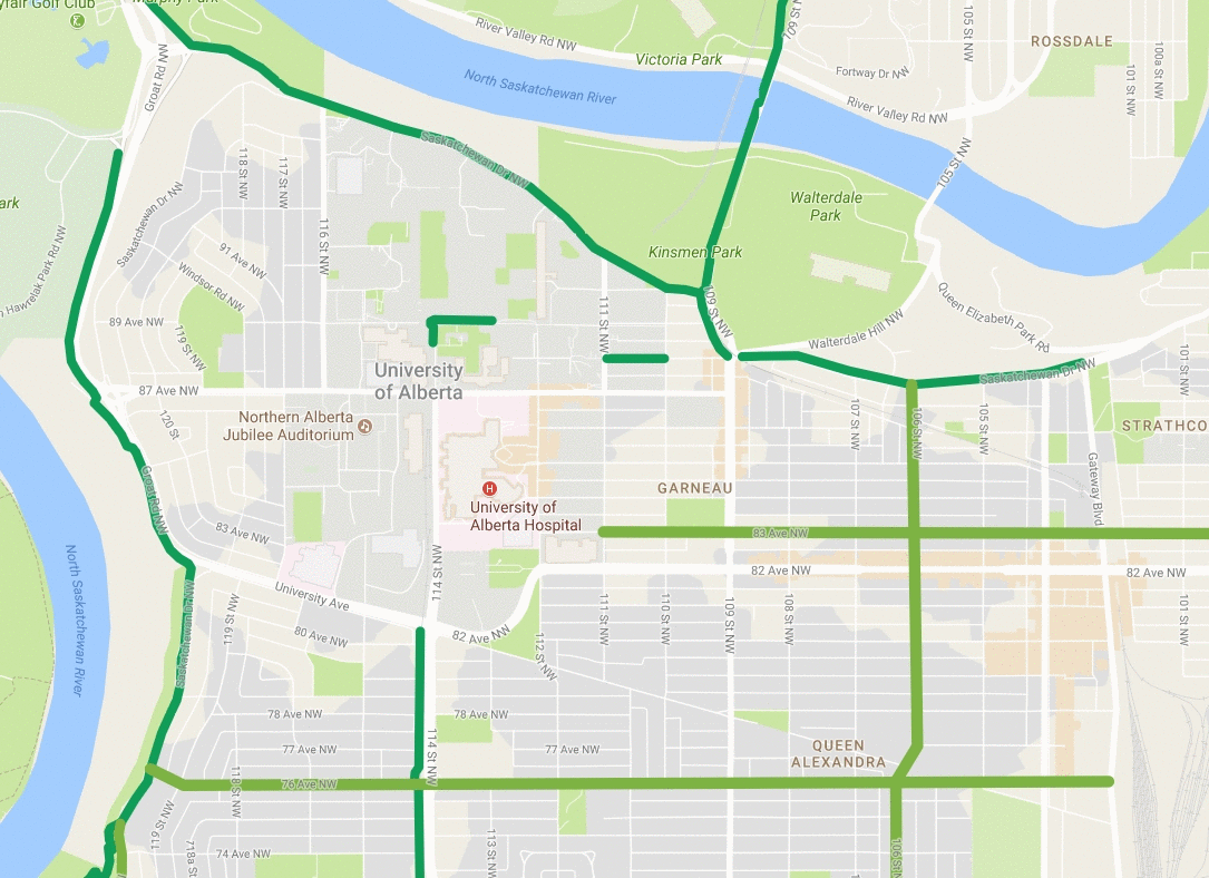
Those additions bring us to here:

In this map the darker green lines show older, reasonably high-quality cycling infrastructure. The lighter green lines show what is being installed this year: the 83ave cycletrack, and the 76ave/106st improvements. The orange lines show some quick-wins that we looked at for 110st and 111st. And the purple lines are what we looked at in Part 1: 116st and 87ave.

That's a good start, and it provides much more connectivity than what we have today, but why stop there?

Warning: this is all complete make-believe, but it doesn't have to be.

114 Street and 87 Avenue

Last time we talked about finding space for a 2-way cycletrack on 87ave by removing the leftturn lane. Here we've done the same thing for 114st.

114 Street around 84 Avenue

Because of the LRT line on the westside of 114st, running the cycletrack on the westside is both good and bad. (more good than bad, though)

It's a bit bad, because it means that anyone biking to the University Hospital would need to cross 114st, and that's annoying.

It's really good though, because it means that there aren't many places where vehicles would ever turn across the cycletrack - 83ave is the only spot. Not having to worry about right or left turners is a huge benefit.

114 Street & University Avenue

And here's where everyone will claim this is impossible.

When the South LRT was built a lovely multi-use trail was included just behind it, running from University Ave to Belgravia. There's one problem, though - you can't get to it. It's not that it's fenced off, but as someone walking you are not legally allowed to cross on the westside of 114st.

If you are walking to the 114st multi-use trail you are required to travel around 3 sides of this intersection in a large "U". And if you are on a bike the only connection is one-block detour down a sidestreet from 115st which then sneaks through the bowels of University's boiler plant. Maybe that expensive multi-use trail was only put there for show?

When the SLRT opened there was traffic chaos, which was caused in part by signalling issues at this intersection. But it's been almost a decade now, and the world hasn't ended. And does anyone remember what traffic was like on 114st before SLRT? It was the exact same thing, except that there were dozens more buses on the road.

So whether or not a cycletrack goes through here, it's long past time for the city to allow pedestrians to legally cross on the westside of the intersection. And if we're doing that anyway, then we might as well add a cycletrack to connect to the orphaned multi-use trail, and from there on to 76ave.

Right now this intersection is so wide that is has a median which takes up two entire lanes of traffic. By reducing that it would be possible to retain the right-turn lane - although right-turns would have to be coordinated with the green for the cycletrack.

112 Street & 83 Avenue

On the other side of the University Hospital is 112st.

It is two-lanes of traffic each way, with a leftturn lane that comes and goes. To install a cycletrack on 112st some spots would look like this - two lanes each way with a leftturn lane, changed to two lanes each way and a cycletrack. In other spots it would go from two lanes each way, to one lane each way, and a leftturn lane, and a cycletrack.

The benefit of adding a cycletrack to 112st is that it could connect to the new cycletrack that is being installed this year on 83ave. That connection isn't really possible from 114st, because the Hospital is in the way. (this would also require extending the 83ave cycletrack to 112st, when the current plan is to stop at 111st. But we're thinking big here.)

112 Street & Whyte/University Avenues

The other benefit of adding a cycletrack on 112st is that it would fix this intersection.

This is another spot that I rode through for a long time, before finally deciding that it was just too much of a risk and giving up. Riding southbound is fine, but riding northbound forces a lone cyclist to stare-down 2 lanes of left-turning traffic. It really is a nightmare, and I'm sure that it gave me nightmares on more the one occasion.

Personally, I don't believe that there is a worse spot anywhere on Edmonton's official bikemap (although I'm open to suggestions). Putting a 2-way cycletrack on the westside of the intersection would greatly simplify things, although now rightturns would have to be coordinated with the cycletrack. But from there people on bikes can connect to the relatively quiet streets of McKernan.

The Updated Map

Here is what we get when we add 114st and 112st in purple.

The fixes and additions that we've looked at - to 110st, 111st, 112st, 114st, 116st, and 87ave - are a total of about 4.5km of new cycletrack. But because of all of the new connections that it provides - to Saskatchewan Drive, 76ave, 83ave, 106st - the overall southside network would be in excess of 15km.

From here there's room for even more improvement - University Ave from 112st to 114st, or 83ave from 112st to 114st, or further north on 110st or 112st, or further west on 87ave, or etc. But compared to what we have now, this would be a great start.

To do this we'd need to remove some lanes, and that sounds scary. But it's important to remember how much the traffic in this area has changed recently. A decade ago 112st and 114st were packed with busses. It wasn't 2-lanes each way - it was 1-lane, and then a wall of ETS blue. Today those busses have mostly disappeared, and that space has been reclaimed by single-occupant vehicles. But it doesn't have to be that way.

Edmonton Bikegrid: Imagining a UofA Cycletrack Minimum Grid - Part 1

This is going to be a continuation of the series of posts about purely hypothetical, future expansions of Edmonton's new cycletrack network.

So far we've looked at:

Next we will look at some options for providing a true, all-ages-and-abilities cycling grid near the University of Alberta.

This is what is currently in place:

The darker green lines here show older, reasonably high-quality cycling infrastructure. The lighter green lines show what is being installed this year: the 83ave cycletrack, and the 76ave/106st improvements. And finally, the orange lines show the quick-wins that we looked at for 110st and 111st.

Warning: this is all complete make-believe, but it doesn't have to be.

116 Street

116st running along the westside of campus currently has painted bikelanes. The city's traffic counts show 8,500 cars per day, and to put that into some context, prior to the construction of the cycletrack network downtown 103st and 106st had 4,500 and 6,500 cars per day respectively. 116st is a farily narrow road though, and the bikelanes are narrow as well. A lot of the traffic on 116st is also short-cutting either to-or-from the river, and so caution is maybe not the highest priority.

With the painted bikelanes I wouldn't bike here unless I had to, and during the winter it wouldn't even occur to me to use this route. The image shows two possible improvements.

The existing bikelanes could be protected by just adding posts. This isn't ideal though, because the bikelanes are quite narrow. Widening the bikelanes isn't really an option either though, because that would reduce the driving lanes to under 10' wide.

An alternative might be to remove the bikelanes, and instead work with the University to widen the sidewalk into a full multi-use trail. That certainly wouldn't be as cheap as just adding posts, but it would probably be more comfortable, and more reliable during the winter (which is when a lot of the University schoolyear takes place).

87 Avenue

Here is where things get more ambitious.

For all of the other cycletrack suggestions we've looked at I've tried to steal space from extra-wide lanes, or maybe by removing on-street parking. But when we get to the major roads around the University the only way to fit in a cycletrack is to remove either a driving lane or turning lane.

What we can see in this image is that the left-turn lane has been removed from 87ave, and replaced with a 2-way cycletrack. And that cycletrack would connect to the 116st bikelanes or multi-use trail that we were just looking at.

87 Avenue & 114 Street

Moving two blocks east to 114st, here the left-turn lane is removed again, and everything is shifted south (the left side in the image). The cycletrack is tucked-in between the plaza infront of the climbing-wall and the on-street parking. The north-south crosswalk here has also been updated to a shared-use crossing.

87 Avenue at 113 Street

Continuing east along 87ave, there isn't much to see here, but doesn't this look better?

Yes, this area is very busy. And yes, leftturn lanes are well-used for an hour each day. But the point of this exercise is to take something that seems impossible - like removing any lane around the university - and to see what it could look like.

87ave is also the only contiguous, east-west route in this area - everything else is blocked either by campus, or by the hospital.

87 Avenue & 110 Street

A bit further east 87ave reduces to one-lane each way with a turnlane. In this image that turnlane is removed, leaving one-lane each way, and the 2-way cycletrack.

This cycletrack provides a connection to the contra-flow lanes on 110st and 111st that we looked at fixing last time.

The Updated Map

The purple lines on this map show where we've ended up:
  • By adding separated cycling infrastructure to 116st and 87ave there is now a loop around the whole campus.
  • This provides connections to Saskatchewan Dr and to the 110st/111st contra-flow lanes
  • It would mean sacrificing something - either driving lanes or turnlanes on 87ave.

That's it for Part 1 of the look at an imaginary University of Alberta cycletrack network. In Part 2 we'll expand it even further, and suggest a few more impossible improvements.

Edmonton Bikegrid Quick-Wins: 110st & 111st Contra-flow Lanes

In the last few posts we looked at an easy extension to the new downtown bikegrid on 100ave and Victoria Promenade, and a slightly-less-easy extension through the Brewery District and Westmount.

Now we're going to move to the other side of the river to look at a quick-win near the University of Alberta.

Warning: this is all complete make-believe, but it doesn't have to be.

111 Street


Right now near the University there are a pair of contra-flow lanes, with 111st northbound and 110st southbound. The thing is, they don't work very well:
  • This route is popular with drivers who are shortcutting through Garneau, and safety is their last concern. I have seen every possible misbehaviour: stopsigns are purely optional; wrongway on the oneways; passing in the bikelanes; and I even had one stoned driver of a white minivan try to pass me on the sidewalk, narrowly missing trees and lampposts.
  • To cross Whyte ave and 87ave you have to climb onto the sidewalk to press a begbutton, which means crossing back-and-forth infront of oncoming traffic.
  • In winter these lanes essentially disappear.

I have a personal connection to these lanes, because I rode them daily for several years. I had so many close calls though, that eventually I gave up and I changed my route. My new route is longer, and it forces me to climb out of the rivervalley every morning, but it's worth it to avoid this existing "bike infrastructure".


Luckily these streets are plenty-wide to add barriers to the existing contraflow lanes to protect cyclists.

This would narrow the driving lanes to act as traffic calming, and would also prevent the "Yes I'm going the wrong way on a one-way, but it's only 1 block so it's okay" syndrome that is so common around the University Hospital.

Adding begbuttons that can actually be reached from the cycletracks would also fix the unsafe crossovers that are required right now.

110 Street

Here we have 110st, which just needs barriers and a cycletrack begbutton at 87ave and Whyte.

If we're dreaming big though, instead of the 2 contra-flow lanes on 110st and 111st, a better approach might actually be to convert 110st to a 2-way cycletrack. This would mean removing the on-street parking, but it would also provide a straight connection from Saskatchewan Drive south to Whyte Ave, and possibly beyond. We can see that better on the map:

The Updated Map

This map shows cycling infrastructure around the University. The darker green lines are older paths. The lighter green lines are new cycletracks that are being installed this year - the new cycletrack on 83ave, and the 76ave and 106st renewal. The orange lines show the quick-fixes on 110st and 111st.

One problem with 111st is that it has to rejoin traffic north of 87ave, so it's really only the 4 blocks from Whtye to 88ave. That's better than nothing, but the nice thing about switching to a 2-way cycletrack on 110st is that it would provide a single connection from Saskatchewan Drive, to the new 83ave cycletrack, and to Whyte. And if we were willing to lose even more parking, it could continue south all the way to the new 76ave cycletrack. That's maybe a bit ambitious, though?

In the short term, adding barriers and begbuttons to fix the 110st and 111st contra-flows would be a quick-win, and it would be a huge improvement over what is there today.