Edmonton Bikegrid: Imagining a UofA Cycletrack Minimum Grid - Part 1

This is going to be a continuation of the series of posts about purely hypothetical, future expansions of Edmonton's new cycletrack network.

So far we've looked at:

Next we will look at some options for providing a true, all-ages-and-abilities cycling grid near the University of Alberta.

This is what is currently in place:

The darker green lines here show older, reasonably high-quality cycling infrastructure. The lighter green lines show what is being installed this year: the 83ave cycletrack, and the 76ave/106st improvements. And finally, the orange lines show the quick-wins that we looked at for 110st and 111st.

Warning: this is all complete make-believe, but it doesn't have to be.

116 Street

116st running along the westside of campus currently has painted bikelanes. The city's traffic counts show 8,500 cars per day, and to put that into some context, prior to the construction of the cycletrack network downtown 103st and 106st had 4,500 and 6,500 cars per day respectively. 116st is a farily narrow road though, and the bikelanes are narrow as well. A lot of the traffic on 116st is also short-cutting either to-or-from the river, and so caution is maybe not the highest priority.

With the painted bikelanes I wouldn't bike here unless I had to, and during the winter it wouldn't even occur to me to use this route. The image shows two possible improvements.

The existing bikelanes could be protected by just adding posts. This isn't ideal though, because the bikelanes are quite narrow. Widening the bikelanes isn't really an option either though, because that would reduce the driving lanes to under 10' wide.

An alternative might be to remove the bikelanes, and instead work with the University to widen the sidewalk into a full multi-use trail. That certainly wouldn't be as cheap as just adding posts, but it would probably be more comfortable, and more reliable during the winter (which is when a lot of the University schoolyear takes place).

87 Avenue

Here is where things get more ambitious.

For all of the other cycletrack suggestions we've looked at I've tried to steal space from extra-wide lanes, or maybe by removing on-street parking. But when we get to the major roads around the University the only way to fit in a cycletrack is to remove either a driving lane or turning lane.

What we can see in this image is that the left-turn lane has been removed from 87ave, and replaced with a 2-way cycletrack. And that cycletrack would connect to the 116st bikelanes or multi-use trail that we were just looking at.

87 Avenue & 114 Street

Moving two blocks east to 114st, here the left-turn lane is removed again, and everything is shifted south (the left side in the image). The cycletrack is tucked-in between the plaza infront of the climbing-wall and the on-street parking. The north-south crosswalk here has also been updated to a shared-use crossing.

87 Avenue at 113 Street

Continuing east along 87ave, there isn't much to see here, but doesn't this look better?

Yes, this area is very busy. And yes, leftturn lanes are well-used for an hour each day. But the point of this exercise is to take something that seems impossible - like removing any lane around the university - and to see what it could look like.

87ave is also the only contiguous, east-west route in this area - everything else is blocked either by campus, or by the hospital.

87 Avenue & 110 Street

A bit further east 87ave reduces to one-lane each way with a turnlane. In this image that turnlane is removed, leaving one-lane each way, and the 2-way cycletrack.

This cycletrack provides a connection to the contra-flow lanes on 110st and 111st that we looked at fixing last time.

The Updated Map

The purple lines on this map show where we've ended up:
  • By adding separated cycling infrastructure to 116st and 87ave there is now a loop around the whole campus.
  • This provides connections to Saskatchewan Dr and to the 110st/111st contra-flow lanes
  • It would mean sacrificing something - either driving lanes or turnlanes on 87ave.

That's it for Part 1 of the look at an imaginary University of Alberta cycletrack network. In Part 2 we'll expand it even further, and suggest a few more impossible improvements.

Edmonton Bikegrid Quick-Wins: 110st & 111st Contra-flow Lanes

In the last few posts we looked at an easy extension to the new downtown bikegrid on 100ave and Victoria Promenade, and a slightly-less-easy extension through the Brewery District and Westmount.

Now we're going to move to the other side of the river to look at a quick-win near the University of Alberta.

Warning: this is all complete make-believe, but it doesn't have to be.

111 Street


Right now near the University there are a pair of contra-flow lanes, with 111st northbound and 110st southbound. The thing is, they don't work very well:
  • This route is popular with drivers who are shortcutting through Garneau, and safety is their last concern. I have seen every possible misbehaviour: stopsigns are purely optional; wrongway on the oneways; passing in the bikelanes; and I even had one stoned driver of a white minivan try to pass me on the sidewalk, narrowly missing trees and lampposts.
  • To cross Whyte ave and 87ave you have to climb onto the sidewalk to press a begbutton, which means crossing back-and-forth infront of oncoming traffic.
  • In winter these lanes essentially disappear.

I have a personal connection to these lanes, because I rode them daily for several years. I had so many close calls though, that eventually I gave up and I changed my route. My new route is longer, and it forces me to climb out of the rivervalley every morning, but it's worth it to avoid this existing "bike infrastructure".


Luckily these streets are plenty-wide to add barriers to the existing contraflow lanes to protect cyclists.

This would narrow the driving lanes to act as traffic calming, and would also prevent the "Yes I'm going the wrong way on a one-way, but it's only 1 block so it's okay" syndrome that is so common around the University Hospital.

Adding begbuttons that can actually be reached from the cycletracks would also fix the unsafe crossovers that are required right now.

110 Street

Here we have 110st, which just needs barriers and a cycletrack begbutton at 87ave and Whyte.

If we're dreaming big though, instead of the 2 contra-flow lanes on 110st and 111st, a better approach might actually be to convert 110st to a 2-way cycletrack. This would mean removing the on-street parking, but it would also provide a straight connection from Saskatchewan Drive south to Whyte Ave, and possibly beyond. We can see that better on the map:

The Updated Map

This map shows cycling infrastructure around the University. The darker green lines are older paths. The lighter green lines are new cycletracks that are being installed this year - the new cycletrack on 83ave, and the 76ave and 106st renewal. The orange lines show the quick-fixes on 110st and 111st.

One problem with 111st is that it has to rejoin traffic north of 87ave, so it's really only the 4 blocks from Whtye to 88ave. That's better than nothing, but the nice thing about switching to a 2-way cycletrack on 110st is that it would provide a single connection from Saskatchewan Drive, to the new 83ave cycletrack, and to Whyte. And if we were willing to lose even more parking, it could continue south all the way to the new 76ave cycletrack. That's maybe a bit ambitious, though?

In the short term, adding barriers and begbuttons to fix the 110st and 111st contra-flows would be a quick-win, and it would be a huge improvement over what is there today.

Edmonton Bikegrid: to the Brewery District & 124st

In the last post, I talked about how easy it would be to expand Edmonton's fantastic new bikegrid west into Oliver along 100ave and Victoria Promenade.

This map shows the new cycletrack network that will be installed this year in light green, and older, relatively high-quality bike infrastructure is in darker green. The orange line is the quick-win extension that we looked at last time.


Next we're going to continue north along 121st to connect to the Brewery district, the downtown grid on 105ave, the multi-use pathway on 121st, 124st, and the 127st cycletrack in Westmount. In this section things won't be quite as painless as they were last time.

Warning: this is all complete make-believe, but it doesn't have to be.

121 Street North of 102 Avenue

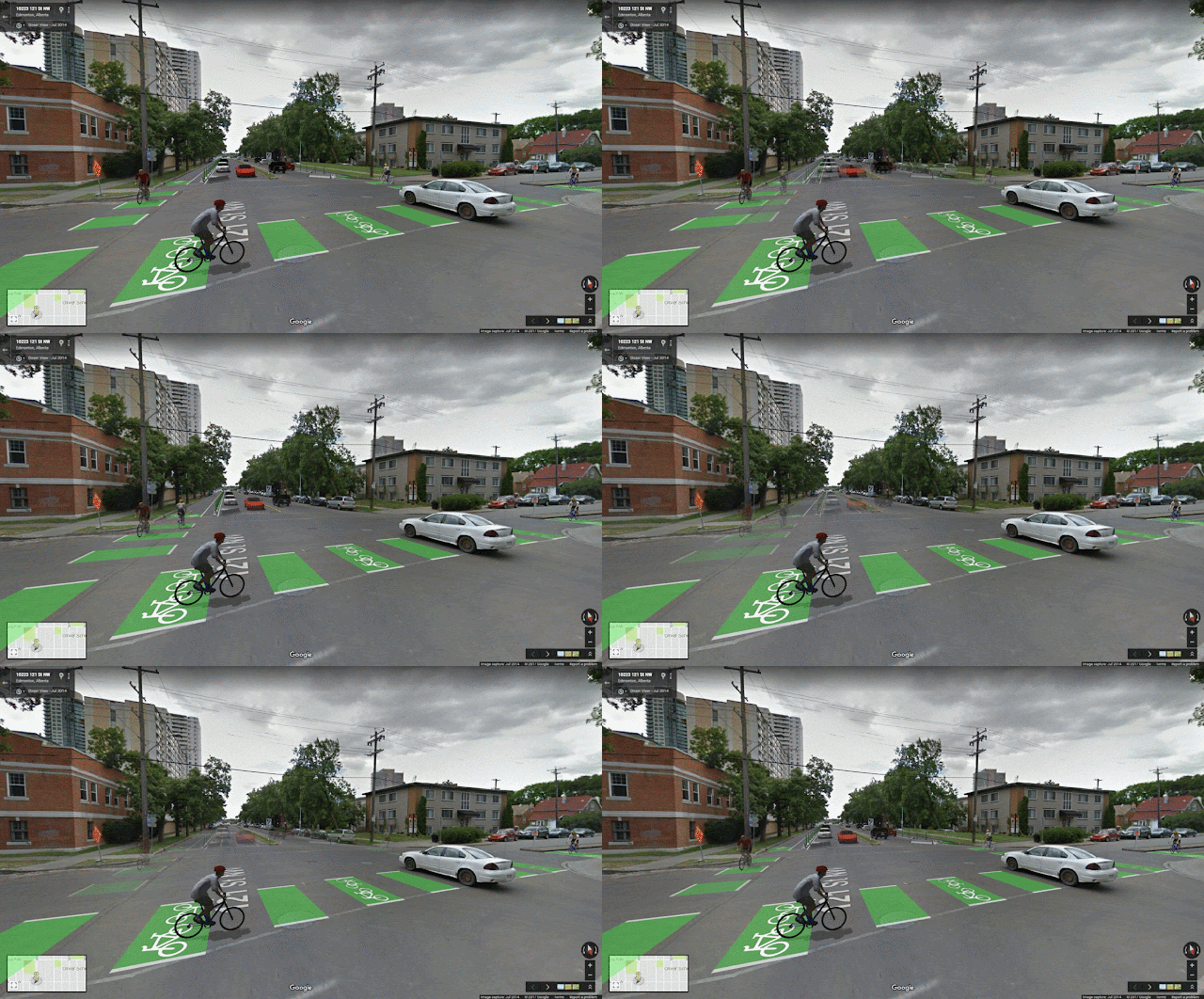
Last time we looked at two options for 121st south of 102ave - either a 2-way protected cycletrack on the eastside of the street, or 1-way protected cycletracks on both sides.

Things are more complicated further north, because the wide median with mature trees means that the road is much narrower. South of 102ave we can add protected cycletracks without losing any parking, but north of 102ave something has to be sacrificed.

If the on-street parking is removed that would give us room for a 2-way cycletrack, and one driving lane.

A 1-way cycletrack is narrower than a 2-way, but it isn't narrow enough to keep the on-street parking. So if we went with 1-way cycletracks on both sides of the street that would mean losing parking on both sides of the street.

This area of Oliver isn't particularly dense - from 102ave to 103ave is just a small walkup and a few houses; and from 103ave to 104ave has houses on the westside, and on the eastside are some lowrises and the Lamplighter highrise.

So it's pretty quiet as far as Oliver goes, but losing on-street parking on both sides probably isn't great. This isn't a quick-win, but of the two options replacing the on-street parking on the eastside of 121st with a 2-way cycletrack probably makes the most sense.

The Brewery District

Whether walking or biking, the Brewery District is currently a wasteland.

A decade ago the area was nothing but security gatehouses, loading docks and used car lots. Today it's trying to be a fancy, hip urban village, but the active transportation connections have not been updated at all: 0 new bikelanes, 0 new path connections, 0 new crosswalks or pedestrian crossings. To walk to the fancy new MEC and Starbucks there is an unmarked crosswalk across 5 lanes of traffic.

Lets fix some of that:

Right now the roads around the Brewery District are massively overbuilt.

On 121st we just saw that it makes the most sense to have a 2-way cycletrack on the eastside of the street. This image shows that, and for the sake of completion it also shows the option of 1-way cycletracks on bothsides.

In either case, there's plenty of room. Extending the cycletrack network is a perfect occasion to narrow these huge roads, and to provide crosswalks and curb-bulbs to improve the walkability of the area as well.

105 Avenue or 106 Avenue

To connect from 121st to 124st we could take either 105ave or 106ave. 105ave is probably better, but the images here will all show 106ave (it was easier to draw).

Both 105ave and 106ave are huge, and have more than enough space to add a protected 2-way cycletrack, without losing any parking or travel lanes.

124 Street

Continuing west on either 105ave or 106ave we reach 124st.

There are traffic lights on 124st at both 105ave and 106ave, and so at either location a pushbutton would need to be installed for easy access from the cycletrack.

And 106ave would require a little bit more work here than 105ave would, because it has a curb-bulb and some trees that would need to be removed.

Connection to 127 Street Cycletrack in Westmount

And finally, here we are continuing west through Westmount to the cycletrack at 127st. This section also isn't pain-free, because it would mean removing on-street parking for 3 blocks.

Westmount is quiet enough that maybe a protected cycletrack isn't needed? But if the goal is a well-connected, all-ages-and-abilities network then this is an important link.

The Updated Map

Last time we looked at extending the cycletrack network west down 100ave and Victoria Promenade, which really could be done with minimal effort.

Here we've continued that extension through the Brewery District and into Westmount. This one isn't quite so easy, but it is important:
  • add 1.4km of protected bikelanes to the network.
  • connect to 105ave cycletrack and the downtown grid
  • connect to 121st mult-use path and 127st cycletrack, providing access further north
  • connect to 124st
  • fix the Brewery District wasteland
  • lose on-street parking along 2 blocks of 121st
  • lose on-street parking along 3 block of 105ave or 106ave
With these additions we'd have a pretty nice grid in place for the 40,000+ people who live in the Downtown, Oliver, Queen Mary Park, and Westmount.

Edmonton Bikegrid Quick-Wins: 100ave & Victoria Promenade

Last week the city opened the first section of Edmonton's new downtown cycletrack network. The official webpage about the grid is here. It is designed for all-ages and abilities, and people riding their bikes are separated and protected from traffic. It is a huge step forward for active transportation in Edmonton.

By the end of this summer, the bike network in Downtown and Oliver will look something like this:


The darker green lines show older infrastructure, and the lighter green is what is being installed this year. The downtown portion of the grid has all been designed and installed in less than a year, which is amazing.

Now that we know what the city can do, lets look at what they should think about doing next.

Warning: this is all complete make-believe, but it doesn't have to be.

100 Avenue

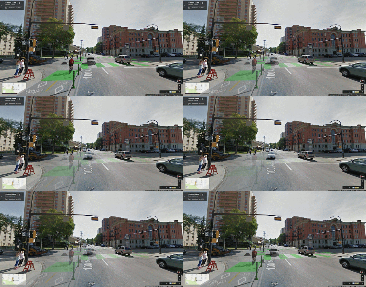
This image shows what 100ave could look like if the cycletrack network were extended west through Grandin.

Once upon a time 100ave had 3 lanes of traffic - 1 eastbound and 2 westbound. Then about 15 years ago the city removed a westbound lane, and converted the road to 2 gigantic lanes.

Right now this is a very unpleasant road to bike on. Drivers don't know if they should hug the middle line, or the curb, or just drive right down the middle. And if you're trying to find someone riding a bike on a sidewalk in Oliver, 100ave is the place to look, because only the bravest people will attempt riding on the road here.

At 16' wide these lanes are huge, and if they were reduced to a more reasonable 10' then a 2-way, protected cycletrack would fit just nicely.

100 Avenue & 116 Street

Heading further west we reach 100ave and 116st, which is a bad intersection if you are on a bike or on foot. When you are on a bike the right-of-ways are completely unclear, and when you are on foot you face a constant battle with drivers creeping into the crosswalks.

At this location the installation of a cycletrack would mean the loss of the short right-turn lane from 100ave northbound onto 116st, as well as roughly 4 on-street parking spots at Academy Place.

But providing a cycletrack would make this intersection navigable on a bike, which is currently impossible. It would also shorten the crossing distance for people walking, and no-right-turn-on-red would limit the crosswalk encroachment that is currently so common.

100 Avenue & 117 Street

If we move a bit further west to 117st we find another intersection that currently doesn't work very well on a bike.

Like 100ave, Victoria Promenade also used to have 2 lanes westbound. One was removed, and it was replaced with a contra-flow bikelane, as well as an extra-wide westbound lane with sharrows. This image shows some possible ways to handle a cycletrack in this location.

The most obvious fix would be to simply widen the existing bikelane into a 2-way cycletrack, and to add barriers. That would be easy, but it would still mean that people biking would need to cross infront of westbound traffic at 117st. If we went with that approach the crosswalk should be converted to a raised crosswalk, so that drivers have to slow down.

An alternate approach would be to shift the bikelane to the northside of the street (the left side of the image), so that people on bikes don't have to cross infront of traffic. That would mean moving the onstreet parking to the other side of the street, which is uncommon in Edmonton, but is not completely unheard of. There is on-street parking on the driver's side on 105st downtown, as well as on Calgary Trail near Whyte ave.

Victoria Promenade

If the cycletrack were placed on the northside of Victoria Promenade it would simplify the major intersections at 117st and 121st. But it also introduces smaller potential conflict points at 118st, 119st, and at the driveways for 6 apartment buildings. This image shows the two options.

A cycletrack on the southside would certainly be simplest, but if it were on the northside the visibility would actually be pretty good.

121 Street & Jasper

The main draw of moving the cycletrack to the northside of Victoria Promenade is because of where 121st crosses Jasper ave.

A 2-way cycletrack on the southside of Victoria Promenade would end up on the westside of this intersection (the right side of the image), and that would not work because of the double leftturn lane.

But a 2-way cycletrack on the southside of Victoria Promenade would connect to the eastside of this intersection, and that could work as long as the traffic signals are set up properly. To find space for that the existing median would have to be demolished (although it's crumbling as we speak), and the lanes shifted over a few feet.

Alternatively, the 2-way cycletrack could split somewhere on Victoria Promenade, and then cross Jasper as separate, 1-way cycletracks.

Connection to 102 Avenue Cycletrack

Finally that brings us to 102ave, which is having a cycletrack installed this year.

Right now the bikelanes on 121st are a narrow afterthought, and they are right in the door-zone of parked vehicles. 121st is really wide though - each direction has 32' of space to play with if we want to improve things.

As we saw with the last image, we could install a 2-way cycletrack, and to do that the median would need to be removed. Or the existing 1-way cycletracks could be improved by moving them against the curb, adding barriers, and then shifting the on-street parking to the outside.

The Updated Map

And here is where we end up, with the orange line showing this quick-win extension.

By installing a cycletrack on 100ave and Victoria Promenade we:

  • add 1.7km of protected bikelanes to the network.
  • add important connections at 110st, to the river at 116st, and to the 102ave cycletrack.
  • fix 3 intersections that are currently bad for biking.
  • provide access to the cycletrack network for Grandin and south Oliver.
  • provide traffic calming by narrowing the huge, existing lanes.
  • lose no lanes of traffic
  • lose less than 10 parking stalls at 116st and at the General Hospital at 111st.
This is all just doodling, but the measurements are pretty accurate, so it should all be possible.

...and we're back (albeit temporarily)

I haven't used this blog in years and years, but I have a few things that I need to write up. This spot is as good as any, so in the next few days there will be some new posts about Edmonton's new bikegrid.